The New Benchmark for Unmanned Systems in Montezuma
Welcome to the Montezuma regional hub of Fair Lifts Unmanned Aerial Services. Nestled in the fertile heart of the Georgia Coastal Plain, we believe that combining cutting-edge robotics with deep-seated local knowledge is the only way to build a sustainable and thriving regional economy. Montezuma is more than a historic crossroads; it serves as the operational core for Macon County’s robust farming and industrial sectors. From the sprawling peach orchards and row crops surrounding Marshallville to the logistical centers near the Flint River, Fair Lifts delivers the technical infrastructure that empowers local enterprises to expand, innovate, and outpace the competition.
Our methodology is rooted in a single principle: information is useless unless it is actionable. For too long, "drone photography" was dismissed as a gimmick—impressive visuals that failed to move the needle on an operational balance sheet. Fair Lifts is redefining the sector. We are transitioning the perception of Unmanned Aerial Vehicles (UAVs) from hobbyist gadgets to indispensable industrial assets. Our background is steeped in professional aviation protocols and rigorous project oversight, ensuring every flight we conduct for a Montezuma partner is executed with surgical accuracy and a nuanced grasp of our specific terrain and climate.
Entrenched in the Macon County Landscape
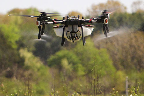
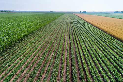
Farming is the lifeblood of Montezuma. Our local producers cultivate some of the highest-yielding peach, pecan, and cotton acreage in the South. Yet, the heavy humidity and loamy sands of the Coastal Plain create logistical hurdles that traditional machinery cannot always clear. Frequent afternoon thunderstorms in Macon County can render fields inaccessible to ground rigs in a matter of hours, stalling critical pesticide applications while pest pressure rises. This is where Fair Lifts takes the lead. We specialize in "Aerial Access." Our heavy-payload spray drones operate when tractors are sidelined by mud, guaranteeing that late-season nutrients and fungicides reach the canopy precisely when the biological window is narrowest.
We are equally dedicated to preserving Middle Georgia’s natural heritage. The Flint River basin is a critical watershed, requiring meticulous management to maintain its ecological integrity. Our environmental specialists use precision UAVs to target invasive flora without the ground compaction or chemical runoff associated with traditional ground crews. By utilizing high-resolution multispectral imagery, we pinpoint infestations with centimeter-level detail, ensuring our interventions are both highly effective and ecologically sound. We aren't just working in Montezuma; we are investing in the longevity of its land.
Professional-Grade Spatial Analytics
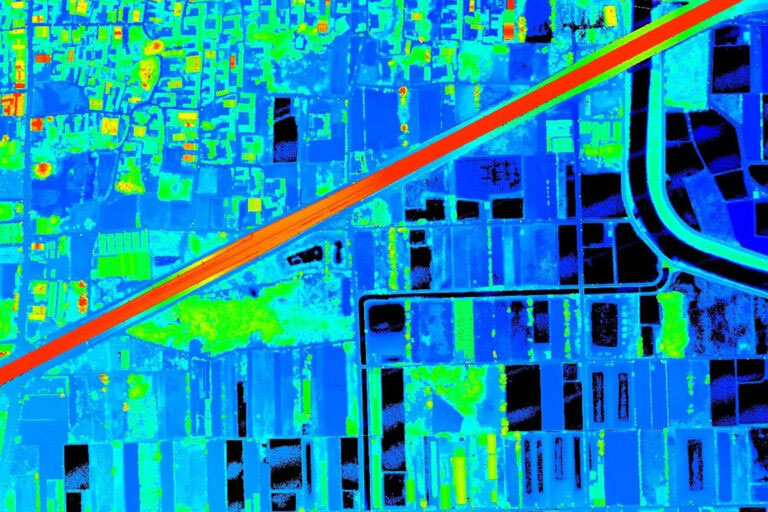
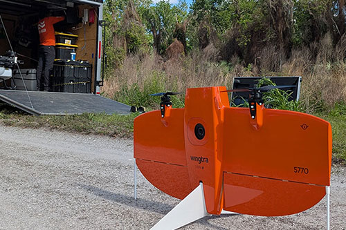
As Montezuma continues to modernize, the requirement for high-fidelity geospatial intelligence grows exponentially. Whether mapping a new solar installation or conducting a structural audit for regional utility providers, there is zero room for error. Fair Lifts Survey & Mapping Services provides the absolute precision—both vertical and horizontal—demanded by engineering standards. Utilizing Blue UAS authorized platforms such as the WingtraOne Gen II and advanced Riegl LiDAR systems, we penetrate even the densest Georgia pine and cypress canopies to generate accurate topographic models.
Our commitment to Montezuma includes a focus on data sovereignty. In a landscape of rising cyber threats, protecting our region's infrastructure data is paramount. Our Blue UAS compliance confirms our adherence to the most stringent Department of Defense protocols for supply chain safety and data encryption. When we survey a Macon County pipeline or grid asset, your sensitive information is shielded from acquisition to delivery. We deliver more than just digital maps; we provide the certainty that comes with secure, elite-level intelligence.
We invite you to discover our suite of specialized aerial services and see how Fair Lifts is enhancing the productivity and safety of Montezuma, GA. Our staff of project managers, agronomists, and certified pilots is ready to consult on your next complex mission. In Macon County, we don’t just watch the horizon; we master it.
Regional Impact
Local Mobilization
Our regional crew is based nearby, offering 24-hour response windows for Macon County, Dooly, Taylor, and Houston counties.
Request Local Response
Ready to Start Your Project?
Discuss your specific goals in Montezuma with a regional expert. We provide rapid mobilization and precision scoping for every regional client.